Kirishima Geopark is an area centered on the Kirishima Mountains, which is a group of more than 20 active volcanoes lying on top of each other. Other than the Kirishima Mountains, there are also a variety of volcanic landforms to visit in the surrounding area, including multiple calderas and Shirasu plateaus.
Volcanic activities not only create landforms, but also various natural environments and ecosystems, and blessings such as hot springs and spring water.
Volcanoes have also influenced lifestyle and culture at the foot of the mountains. The influence of volcanoes can be seen in the stone culture and belief in volcanoes (shrines, etc.) that remain in various areas, as well as in the food culture of the region, including local specialties such as imo-jochu (sweet potato shochu) and tea.
A place where you can think about “what is a volcano” and experience the way of life and the culture of people who have lived at the foot of an active volcano, that is what Kirishima Geopark.
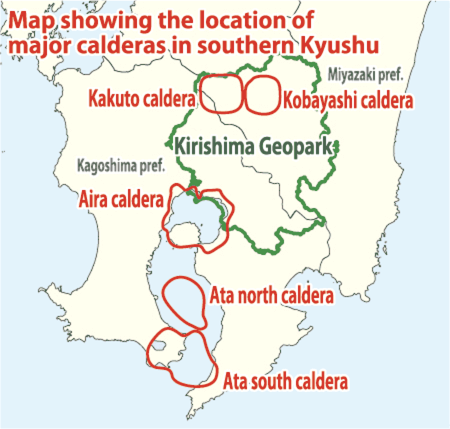
Caldera
A landform formed during an eruption, when a large amount of magma that had accumulated underground erupted all at once, causing the ground to plunge and sink into the hollowed-out beneath. A caldera eruption is a massive eruption of a magnitude such that once it occurs, it can destroy the surrounding civilization, and such eruptions occur once every few tens of thousands of years in Southern Kyushu.
Shirasu
The accumulation of large pyroclastic flows (a phenomenon in which volcanic ash, pumice, hot gasses, etc. flow in unison) that erupted during caldera eruptions. Shirasu is a folk name in Southern Kyushu and generally refers to the Ito Pyroclastic Flow deposit that erupted from the Aira Caldera about 30,000 years ago. A Shirasu plateau is the landform formed after a pyroclastic flow deposit that filled plains and valleys has been eroded.
Landforms and Blessing Created by Volcanoes
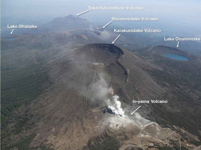
Smoke coming out of the Kirishima Mountains (2018)
The Kirishima Mountains have erupted repeatedly up to this day.
Lava that flew from past eruptions has formed hills like the Ikoma Plateau. In addition, new mountains and alluvial fans were created at the foot of Hinamoridake Volcano, due to its collapse during eruptions.
Today, the tops of those landforms are used for land use as ranches and orchards. In addition, water from the springs that gush out from under the easily permeable strata made out of the volcanic eruptions, is used for local industries such as fish farming as well as for domestic use.
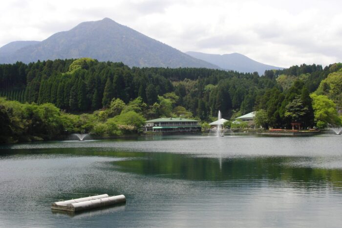
Idenoyama Spring
It gushed out from a part of the mountain body when Hinamoridake Volcano erupted and collapsed about 40,000 years ago. It has been selected as one of the “Best 100 Bodies of Water” by the Ministry of the Environment, and sturgeon farming and other activities are conducted using the abundant water supply.
Karakunidake Volcano
Kirishima’s highest peak (1,700 meters above sea level), with multiple craters that open wide on the summit and mountainside. Ikoma Plateau is located on solidified lava that flowed out from Karakunidake Volcano (or Koshikidake Volcano).
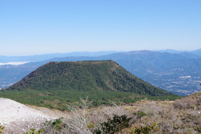
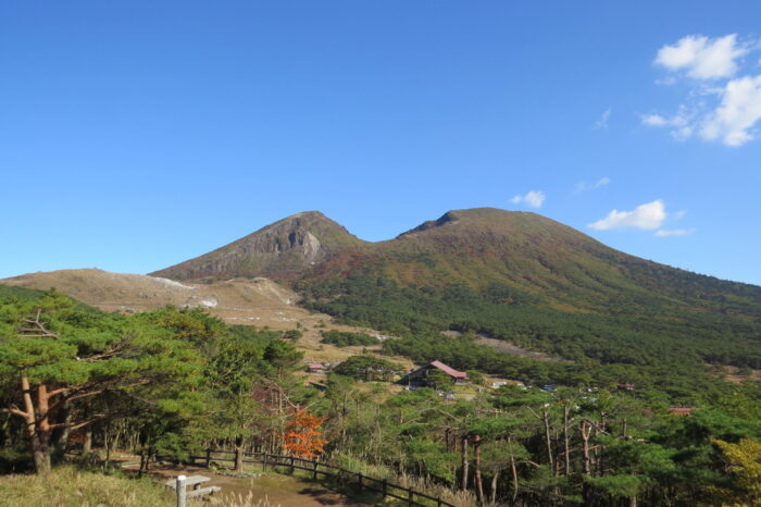
Koshikidake Volcano
There is a shallow crater at the top of the mountain, and a grassland (low marshland) extends within it. The end of the lava that flowed out from Koshikidake Volcano to the north reached the foot of the mountain, and a part of the Miyazaki Expressway next to the solidified lava is built as if it’s trying to avoid the rocks.

Nanaore Falls
A waterfall cascading over the lava rocks that flowed from Koshikidake Volcano. The name is said to have come from the complicated winding of the flow path, and the reddish color of the rock surface is caused by the hot spring water that flows into it.